In the Fall of 2012 the City of Atlanta contracted with the Georgia Tech Center for GIS and the Center for Quality Growth and Regional Development (CQGRD) to quantify the tree canopy in the city. The data used was collected in 2008.
The result of this work is published on the Preserving the City of Trees website and the data is very accessible; in particular the UTC Assessment Story Map and Trees Atlanta Interactive Map.
FROM THE DATA
- Atlanta has the highest percentage of tree cover compared to 17 other major cities in the U.S.
- Within the Atlanta city limits, 47.9% of the total land is covered by urban tree canopy.
- The majority of the total canopy, 77.3%, is on single-family residential land (neighborhoods).
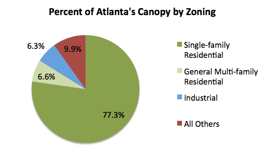
Data from Georgia Tech, Trees Atlanta and The City of Atlanta [3]
- For single-family residential land, 60.7% is covered by urban tree canopy.
- Of the over 200 neighborhoods identified, tree cover varies from a high of 83% to a low of 3%
This study shows that neighborhoods are the most important stakeholders in preserving Atlanta’s canopy.
TRENDS
By 2014, Trees Atlanta, founded in 1985, had planted over 100,000 trees. Trees Atlanta has been a powerful force for good, helping to maintain and expand the urban canopy.
But trends are concerning and many trees have been removed. Neighborhoods in particular are losing trees at an alarming rate. The current City Tree Protection Ordinance is weak and does little to actually protect existing trees.
New data is due out soon. It will be interesting to see how the canopy has changed but in many of our neighborhoods the losses have been staggering.
References
[1] Georgia Tech: Preserving The City Of Trees
[2] Georgia Tech & The City of Atlanta: UTC Assessment Story Map
[3] Georgia Tech, Trees Atlanta & The City of Atlanta:: Trees Atlanta Interactive Map
